


Creating an accessible city is about much more than removing architectural barriers. It means ensuring that everyone, regardless of age, physical ability or temporary mobility limitations, can move through public spaces safely, comfortably and independently. Achieving this requires a detailed understanding of how people interact with the urban environment and, above all, a way to transform observations into practical actions.
Across Europe, achieving this objective also requires new professional competences capable of integrating technical knowledge, digital tools and accessibility principles into everyday planning. One of the goals of the AccessCoVE project is precisely to strengthen vocational education and promote innovative methodologies that support evidence-based accessibility planning. Within this context, Geographic Information Systems (GIS) represent one of the digital tools that can significantly improve decision-making for municipalities and accessibility professionals.
This is where Geographic Information Systems (GIS) have become an essential ally for urban planners. Often associated simply with digital maps, GIS is in fact much more than a mapping tool. It provides a common platform where data collection, spatial analysis, planning, cost estimation and long-term monitoring come together, helping municipalities make informed decisions and develop more inclusive public spaces.
The importance of digital tools such as GIS reflects the objectives promoted by the AccessCoVE project, which encourages innovation, collaboration and the development of professional competences to improve accessibility across Europe.
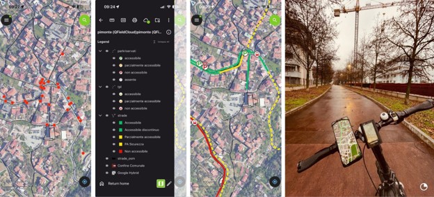
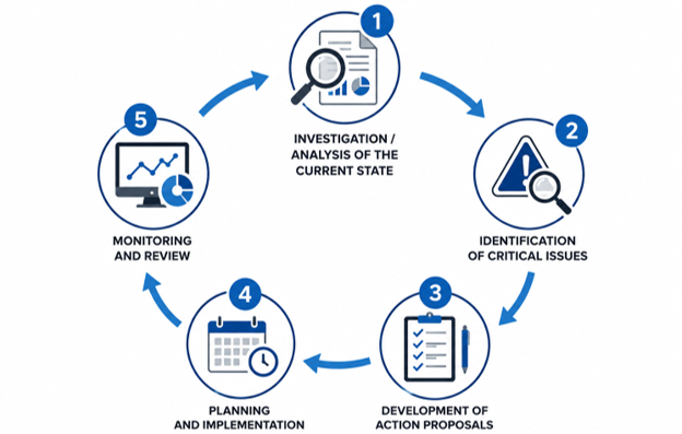
One of the greatest strengths of GIS is that it supports the entire accessibility planning process, beginning with field surveys. Before any technical work starts, municipalities and planning teams identify together the streets, public buildings, parks and public spaces that will be inspected. These are not selected randomly but according to the characteristics of the municipality, local priorities and the importance of the spaces within everyday life.
During inspections, every observation is recorded directly in the GIS environment. Instead of relying on handwritten notes or separate spreadsheets, surveyors collect information in real time, linking each barrier to its exact geographic location. Photographs, measurements and technical notes become part of a single digital database that accurately represents the municipality and can be consulted throughout every stage of the project.
For accessibility professionals, this digital workflow improves not only the quality of data collection but also the consistency of assessments carried out by different technicians. Developing these competences is one of the challenges addressed within the AccessCoVE project.
This georeferenced approach also allows each street to be analysed in greater detail. Rather than treating an entire street as a single element, it can be divided into smaller sections with similar characteristics. Sidewalk width, pavement conditions, slopes or pedestrian crossings often change along the same road, and evaluating these sections individually provides a much more realistic understanding of accessibility. GIS automatically calculates elements such as the length of each section while keeping all information organised and easy to retrieve.
However, collecting data is only the first step. The real value of GIS lies in its ability to transform observations into decisions.
Accessibility barriers vary enormously in their nature and complexity. Sometimes restoring an accessible route is surprisingly simple: trimming vegetation that blocks part of a sidewalk, repairing damaged paving or improving a curb ramp may be enough to ensure continuity along a pedestrian path. In other situations, more significant interventions are required, such as rebuilding sections of pavement, redesigning pedestrian crossings or introducing raised crosswalks to improve both safety and accessibility.
Contrary to what many people imagine, accessibility planning does not necessarily involve large-scale redevelopment projects. In many cases, carefully targeted interventions can produce substantial improvements while remaining affordable for municipalities. GIS helps identify exactly where these interventions are needed, allowing available resources to be invested where they will have the greatest impact.
Of course, no municipality has unlimited resources. One of the biggest challenges is deciding where to intervene first, especially when accessibility barriers are widespread across the territory. This is why prioritisation becomes such an important part of the planning process.
Rather than relying solely on subjective judgement, GIS makes it possible to combine different sources of information into a structured evaluation system. Technical survey results are considered alongside contributions collected through participation activities, recommendations from municipal technical offices, the continuity of pedestrian routes and the functional role of each location within the urban network.
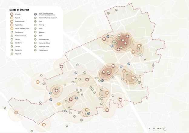
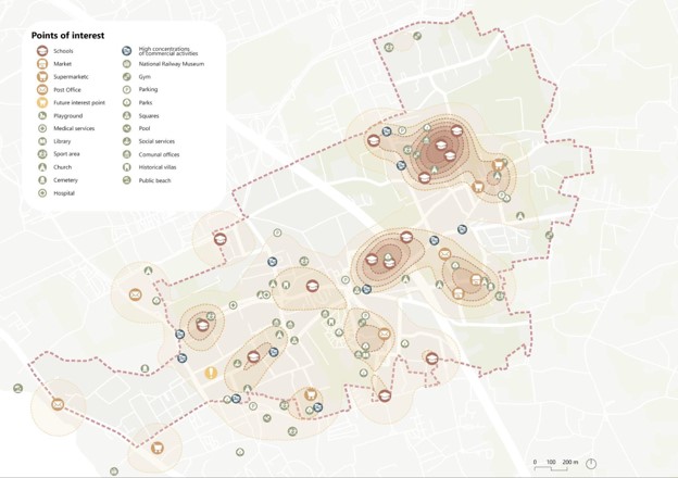
The functional importance of a location is assessed by considering the services and destinations found within approximately 100 metres.
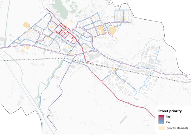
These may include places of worship and cultural landmarks, public buildings and services, parks and green areas, commercial activities, healthcare facilities, sustainable mobility infrastructure and planned public works. Integrating these factors into the prioritisation process supports a cost-benefit evaluation of proposed interventions, helping municipalities focus investment on projects that improve accessibility for the largest number of users while making efficient use of public resources.
Because all this information is stored within the GIS database, priorities are never fixed permanently. As interventions are completed and urban conditions change, the municipality can update the evaluation and redefine future priorities without having to start the entire assessment from the beginning.
This structured approach also facilitates transparent decision-making, allowing technical offices, policy-makers and citizens to understand why certain interventions are prioritised over others. Shared methodologies of this kind are essential for improving accessibility planning across different European contexts.
The same approach applies to public buildings. Accessibility is not limited to streets, parks and sidewalks but also concerns the places where citizens access essential services. Building entrances, internal routes, ramps, level differences and sanitary facilities all contribute to the overall accessibility of a public building.
Using a common methodology for both public spaces and buildings helps accessibility professionals produce more consistent assessments and supports municipalities in developing integrated accessibility strategies.
In many situations, the objective is not to redesign an entire building but to make the best possible use of existing spaces through practical improvements. Some interventions are relatively straightforward, while others, such as adapting accessible toilets, may require more substantial works. In every case, GIS provides a clear overview of existing conditions and ensures that every proposed intervention is accurately documented and located.
The usefulness of GIS does not end once the accessibility plan has been completed. On the contrary, one of its greatest strengths is its ability to support municipalities long after the surveys are finished.
Every surveyed element receives its own unique identification number linked to precise geographic coordinates. Proposed interventions, technical information, photographs and estimated costs remain connected to that location inside the database. Preliminary cost estimates become part of the GIS database alongside technical information, proposed interventions and spatial data. Because prices naturally change over time, the digital platform allows budgets to be revised without rebuilding the entire accessibility plan. In this way, GIS helps transform the plan from a static document into a dynamic management tool that can support municipalities throughout the life of the project.
The result is much more than a collection of maps. Municipal technical offices receive a digital database that allows them to locate every barrier quickly, retrieve all related information and continue developing projects without repeating surveys or searching through extensive documentation. The GIS database becomes a shared working environment that facilitates communication between planners, designers and municipal technicians. This reflects the objectives of the AccessCoVE project, which is developing training frameworks for new professional roles such as the Accessibility Certifier and the Accessibility Consultant. Providing these professionals with a common digital environment and shared methodology helps ensure that accessibility assessments, planning and implementation remain consistent, coordinated and evidence-based. This collaborative approach reflects also the interdisciplinary nature of the professional roles promoted by AccessCoVE, where planners, accessibility consultants and public authorities work within a common decision-making framework.
Perhaps even more importantly, it also creates the foundations for continuous monitoring. Accessibility should never be considered a one-off achievement but an ongoing commitment that evolves together with the city. Infrastructure changes, new developments are built and community needs continue to evolve. For this reason, the accessibility plan must remain a living document rather than a report that is archived and forgotten.
Together with the GIS database, municipalities can use a monitoring checklist that establishes common evaluation criteria for future inspections. By periodically revisiting the surveyed locations, technicians can verify whether barriers have been removed, whether completed interventions remain effective and whether new accessibility issues have emerged. Since every element is already georeferenced and uniquely identified, comparisons over time become straightforward, allowing municipalities to monitor progress consistently and base future decisions on reliable evidence.
In this way, GIS supports not only today’s planning but also future accessibility management. Its georeferenced database allows municipalities to monitor interventions and update information over time, something that would be much more difficult using traditional reports alone.
Digital technologies are increasingly changing the way accessibility is understood and managed. GIS demonstrates that maps are only the beginning. When combined with technical expertise and collaborative planning, spatial information becomes a powerful decision-making tool capable of supporting more transparent processes, more efficient investments and, ultimately, more inclusive communities.
These principles are at the heart of the AccessCoVE project, which promotes innovation, collaboration and the development of skills that help professionals respond to accessibility challenges with practical, evidence-based solutions.
As a partner in the AccessCoVE project, Città Sotto Scacco Srl (CSS) contributes its experience in applying GIS to accessibility planning through PEBA methodologies in Italy. This practical experience demonstrates how digital tools, shared methodologies and specialised professional competences can support municipalities in planning, implementing and monitoring accessibility more effectively. By fostering these approaches, AccessCoVE contributes to building a new generation of accessibility professionals capable of delivering evidence-based solutions for more inclusive cities.


Project n. 101103097
Funded by the European Union. Views and opinions expressed are however those of the author(s) only and do not necessarily reflect those of the European Union or European Education and Culture Executive Agency (EACEA). Neither the European Union nor the granting authority can be held responsible for them.
Offriamo all’Amministrazione Pubblica la consulenza necessaria per ripensare un modello di città più vivibile e a misura d’uomo.
Oppure contattaci direttamente ai seguenti recapiti:
- info@cittasottoscacco.it